

 Rafraîchir
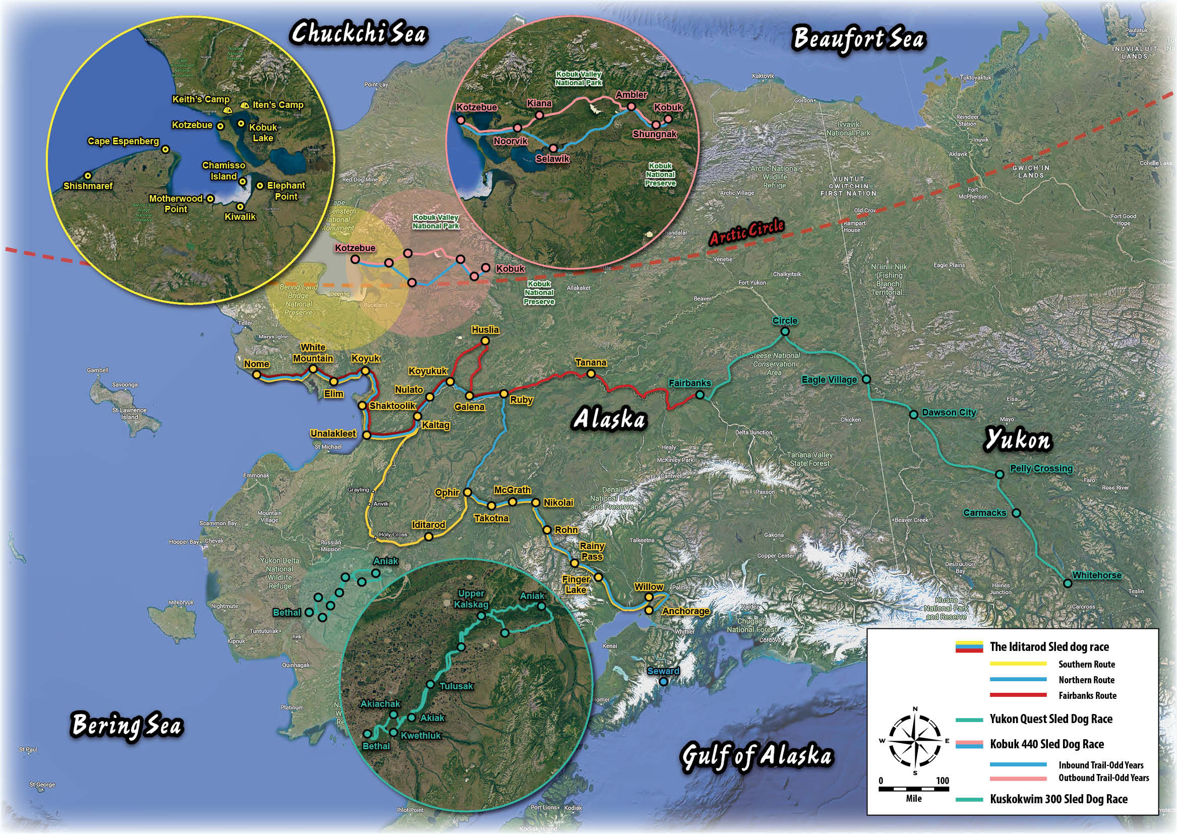
Alaska Artistic Rendering Map of Trails and Locations
Vous souhaitez remporter un projet comme celui-ci ?
Ce client a reçu 11 designs graphiques de la part de 4 designers. Il a choisi ce design graphique de Riaz786 comme design gagnant.
Inscrivez-vous Trouvez des Projets de Design
- Garanti
-
 US$190
-
 11 designs
-
 4 designers
Brief de Design Graphique
This is an artistic map of Alaska, with a priority on beauty, that indicates where certain dog race trails and locations are. The trails will include: The Iditarod Sled dog race, the Yukon Quest Sled Dog Race, the Kobuk 440 Sled Dog Race, the Kuskokwim 300 Sled Dog Race. Place names that will have special highlight include Fairbanks, Anchorage, Seward, Nome, Kotzebue, and other key checkpoints along the dog race trail. There will be one inset area of Kotzebue which will include the Baldwin Peninsula and will highlight Kotzebue, a location NE of Kotzebue called Keith's Camp, another location further NE called Iten's camp. There should be a legend depicted the trails. As with the example attached the emphasis is on artistry rather than geographic accuracy. This isn't a GIS project but intended to help the reader get an overall sense of the area and distance.
Marché(s) Cible(s)
Audience are readers of an adventure memoir that want to know more about life in Alaska and dog mushing.
Styles de police à utiliser


Autres polices appréciées:
- A combination of fonts would be best. The map will need to be easily read so a serif or sans serif will be needed for the small print. Perhaps a more decorative font could be used for the titles of the race names or the oceans etc...
Couleurs
Couleurs choisies par le client et à utiliser dans le design de logo:
Aspect
Chaque curseur illustre les caractéristiques de la marque client et le style que doit transmettre votre design de logo.
Élégant
Audacieux
Léger
Sérieux
Traditionnel
Moderne
Sympathique
Professionnelle
Féminin
Masculin
Coloré
Conservateur
Économique
Haut de gamme
Exigences
Doit avoir
- My project must have the state of Alaska and the northwestern portion of Canada, the trails detailed in the project description, the place names listed, the inset in the powerpoint, a legend to make it clear what is what. I would like the major oceans listed, the arctic circle listed along with the major political boundaries of the US, Canada, Yukon Territory, and British Columbia. The sample map that is in the powerpoint is a great example of the place names that should be included in our map. Perhaps incorporate imagery of the Northern Lights in the background of the map.
Bien d'avoir
- I want this to be a beautiful representation of Alaska that helps the reader to understand the places conceptually. It could be in one page but if it needs to be two that is acceptable. Some topography may be nice.
Ne doit pas comporter
- Nothing comes to mind. Despite needing to have a lot of data points I don't want it to be overly 'busy'.